Hi, I'mAbdul-Karim W. Fuseini
I am
Dedicated Geoinformation Engineer with a strong commitment to driving the successful implementation of geospatial solutions. My self-driven approach and flexibility allow me to lead projects effectively, leveraging my passion for geospatial technology.
About
![]() I am a Master's student specializing in Photogrammetry and Geoinformatics at the Hochschule für Technik Stuttgart.
Driven by a commitment to advancing location intelligence and spatial data interoperability,
I focus on creating innovative solutions that bridge technology with sustainable development.
With my experience in spatial data engineering, spatial data analysis, visualization, and project management, I take pleasure in performing thorough analyses and presenting results in an easily understandable way,
catering to both technical experts and non-technical audiences.
I am a Master's student specializing in Photogrammetry and Geoinformatics at the Hochschule für Technik Stuttgart.
Driven by a commitment to advancing location intelligence and spatial data interoperability,
I focus on creating innovative solutions that bridge technology with sustainable development.
With my experience in spatial data engineering, spatial data analysis, visualization, and project management, I take pleasure in performing thorough analyses and presenting results in an easily understandable way,
catering to both technical experts and non-technical audiences.
- Software: ArcGIS Pro, QGIS, MATLAB, FME, ERDAS, ENVI, SNAP, Sparx's Enterprise Architect
- Solutions: ArcGIS Online, ArcGIS Enterprise, ArcPad
- Languages: Python, R, JavaScript, HTML & CSS
- Databases: PostgreSQL, SpatiaLite, MySQL
- Libraries: GDAL, rasterio, Folium, GeoPandas, Google Earth Engine, Plotly
- Frameworks: GeoDjango, Flask, Streamlit
- Tools: ODK, Kobo Collect, ESRI Field Apps, QField
- Other Technologies: Git & GitHub, Microsoft Office Software, Zoom
I am seeking an opportunity to utilize my abilities and skills to drive business success while gaining valuable professional development and enriching experiences.
Experience

- Surveyed and managed location data of over 2000 cocoa farmlands for the development of the Cocoa Management System (CMS).
- Checked & validated the accuracy & precision of surveyed data (on-site and in the office).
- Conducted community entry exercises to engage with farmers on the need to participate in the CMS project.
- Organized and compiled weekly data for district and regional level integration.
Tools: ArcMap, ArcPad, GPS

- Developed and conducted Statistical and QGIS data analysis tutorials for students.
- Conducted literature reviews detailing findings & summarizing studies.
- Conducted on-site interviews using structured & unstructured interview questions.
- Contributed in publishing a research study (proposing a new spatial database framework for pedestrian indoor navigation) in peer-reviewed journals.
- Coordinated data collection with other ad hoc research staff.
- Cleaned and organized spatial and non-spatial data for the development of the myTroski mobile app that facilitates navigation.
Tools: QGIS, SNAP, SPSS, Google Earth Pro

- Spearheaded data collection, monitoring & validation using geospatial resources while ensuring data quality and integrity standards.
- Supported staff through the Energy Research Group to create an effective organizational framework for collaborative interdisciplinary research & development.
- Supported the Energy Research Group through the measurement of building roofs for solar PV needs assessment using GIS and remote sensing data.
Tools: QGIS, Google Earth Pro, ArcMap
Projects
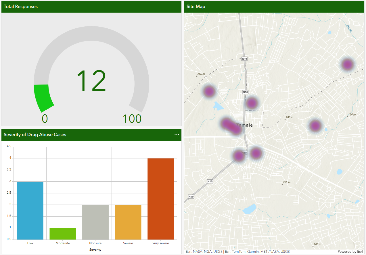
This Project demonstrates how ArcGIS Survey123 can be used for illicit drug vending/abuse mapping and analysis.
- Tools: ArcGIS Survey123, ArcGIS online, and ArcGIS Dashboards Key Tasks:
- Implemented an ArcGIS survey123 questions for field data collection.
- Integrated data into the ArcGIS Dashboard for visualisation.
- Try it here by submitting a SURVEY: SURVEY link
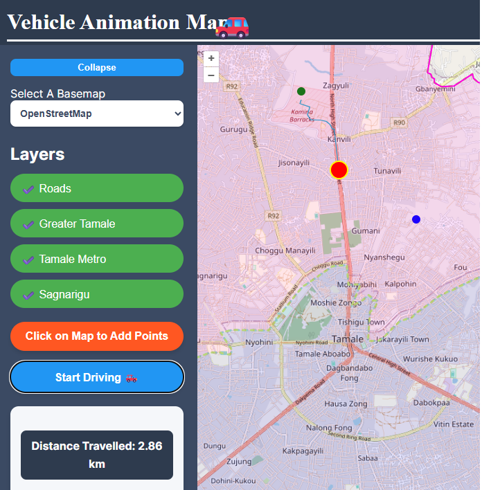
This app is used for routing or finding the shortest path within a network (Tamale).
- Tools: Python, React, CSS, HTML, OpenLayers, QGIS Key Tasks:
- Implemented interactive route planning with shortest-path calculation.
- Integrated GeoJSON layers with toggle and styling.
- Animated vehicle along routes with distance tracking.
- Optimised map performance and deployed to GitHub Pages.
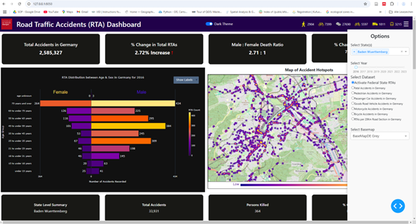
Designed and implemented an interactive dashboard for Unfallatlas data to enable spatial analysis, filtering, and trend visualizations.
- Tools: Python, Plotly Dash, Leaflet, PostgreSQL/PostGIS, QGIS, GeoServer Key Tasks:
- Reviewed literature on Road Accidents, dashboard development, design theories, data sources, and technologies
- Integrated Unfallatlas accident data into a unified dashboard.
- Developed interactive Leaflet maps to visualize accident locations and hotspots.
- Assessed user feedback on interactivity and usefulness.
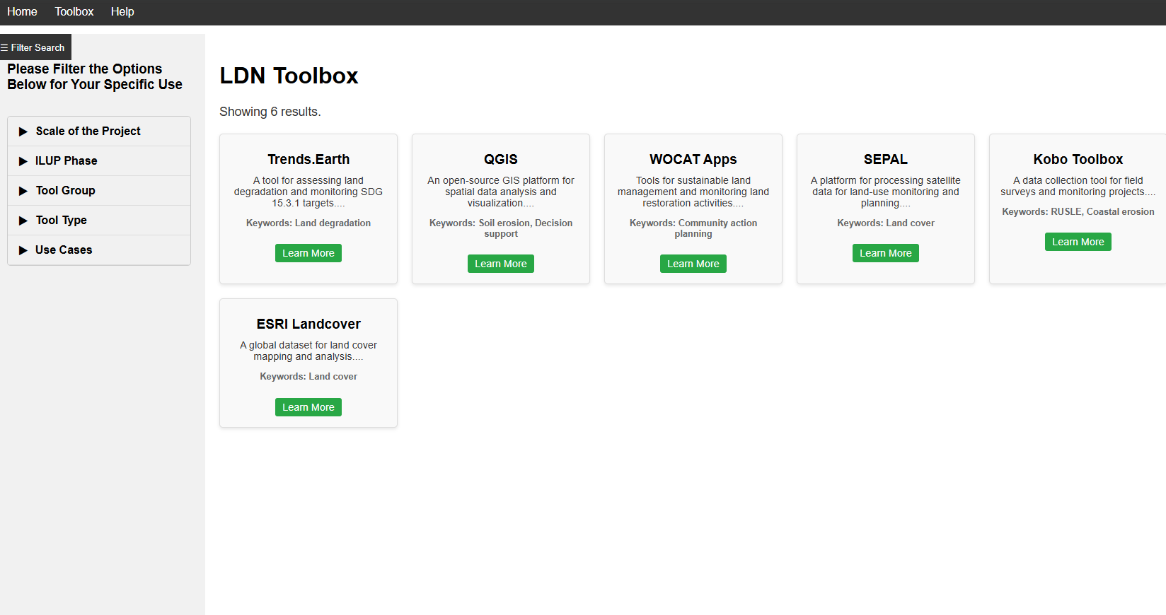
Geo-LDN Toolbox Mockup: Enhancing User Experience for Tool Search and Access.
- Tools: HTML, CSS, JavaScript Key Tasks:
- Designed a user-friendly web mockup to simplify searching and accessing tools within the GEO-LDN Toolbox.
- Developed an intuitive interface to help users quickly find relevant land degradation monitoring and analysis tools.
- Focused on improving navigation and filtering functionality to support diverse user needs.
- Used HTML, CSS, and JavaScript to prototype responsive and interactive design elements for the upcoming GEO-LDN website.
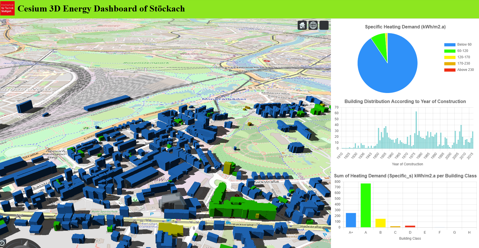
Web-Based 3D Visualization of Building Energy Efficiency Using CityGML and CesiumJS.
- Tools: HTML, CSS, CesiumJS, Chart.js, FME Key Tasks:
- Converted CityGML data to 3D Tiles using FME for web-based visualization.
- Integrated CSV and CityGML data via FME’s Feature Joiner.
- Developed an interactive 3D dashboard with CesiumJS and Chart.js.
- Styled buildings by energy efficiency and implemented zoom-based chart filtering.
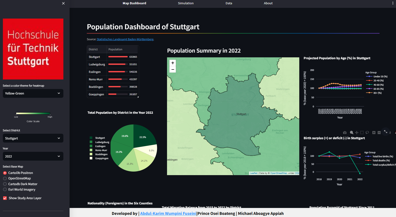
Exploring Open Data - Creating an Online Map for Analyzing Population Growth.
- Tools: Python, Streamlit, PostgreSQL/PostGIS, FME, QGIS Key Tasks:
- Identified and studied literature related to the topic
- Utilized web crawling techniques to automatically extract data HTML tables from the Statistisches Landesamt Baden-Württemberg website.
- Integrated and store the collected data in the PostgreSQL database for further post-processing and analysis.
- Built a WebGIS Dashboard for the visualization of the collected data with appropriate charts/graphs
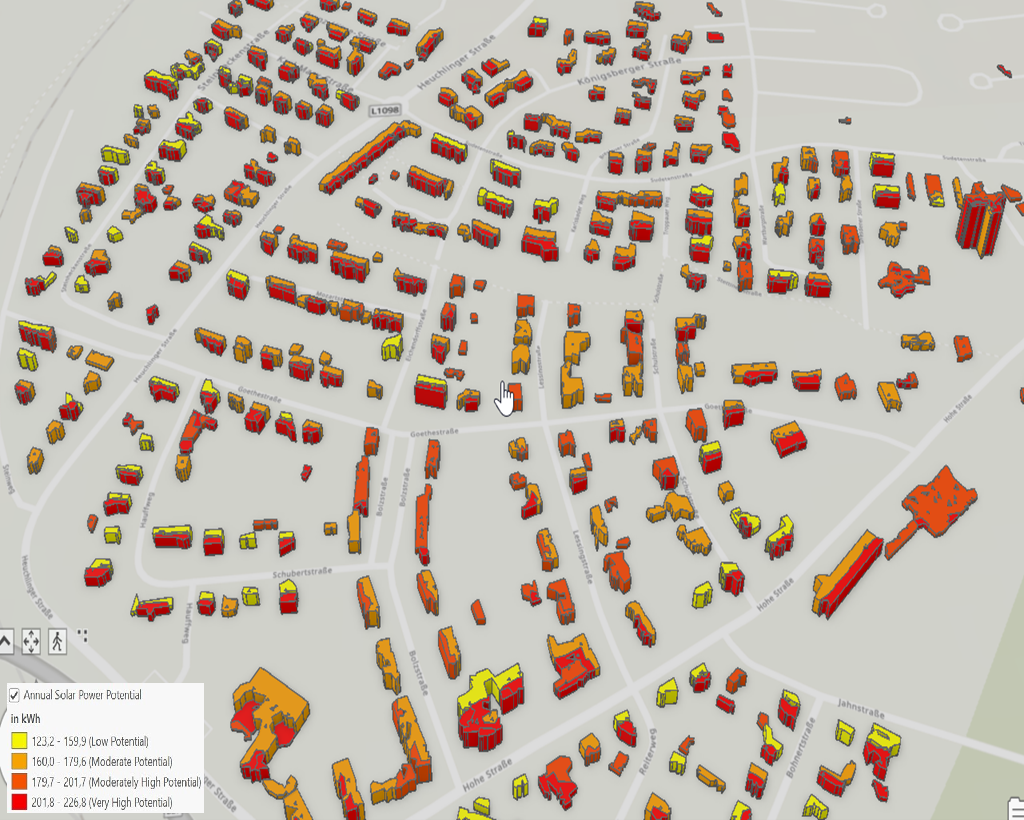
Solar-Photovoltaic Suitability Analysis in Jagstfeld, Bad Friedrichshall, Baden Württemberg, Germany
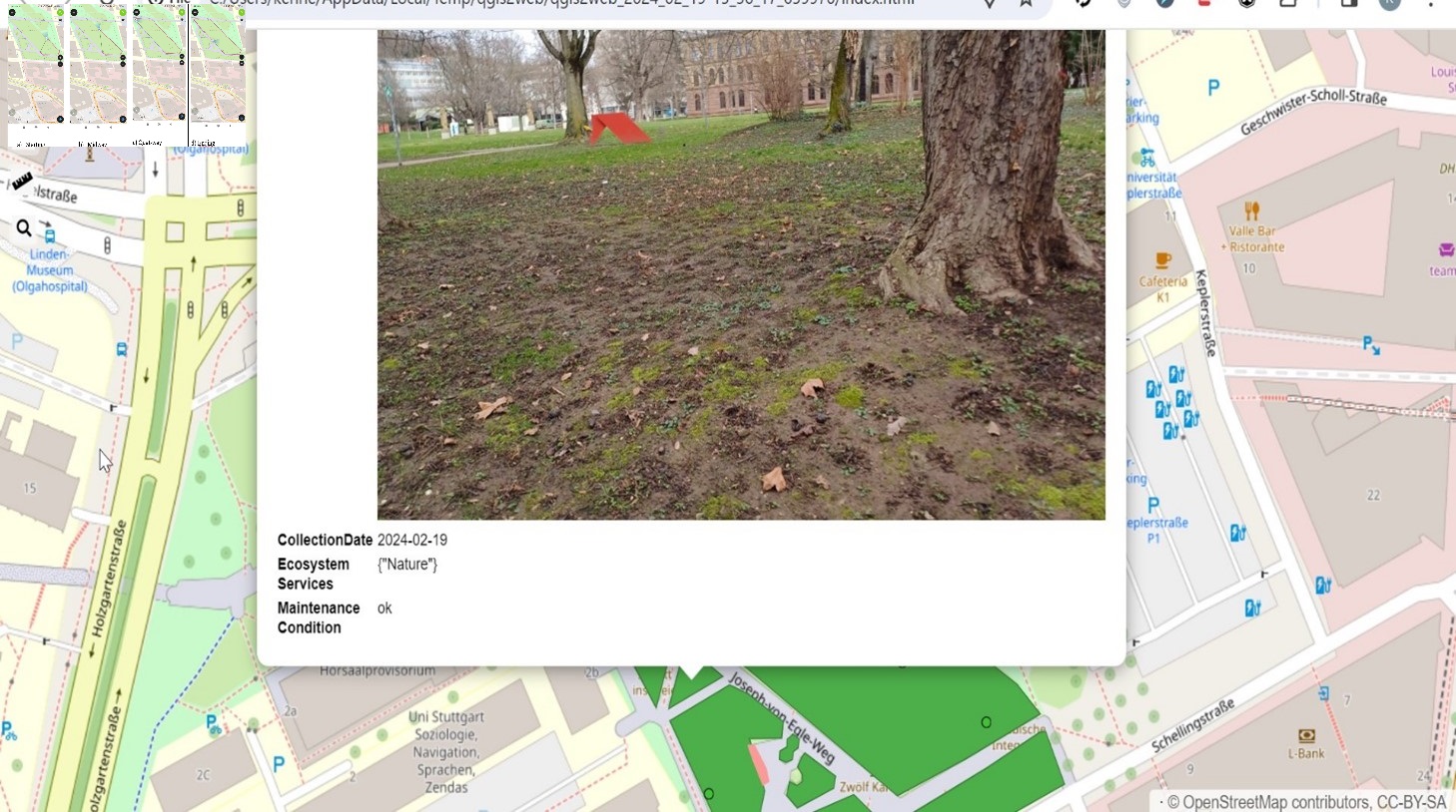
Implementing an assessment tool for Ecosystem Services in QGIS as an Open-source Software
- Tools:QGIS, QField, QGIS2Web Key Tasks:
- Configured a mobile data collection app on an Android smartphone using QField
- Tested the application in the field by collecting sampled data
- Configured a Web application for the visualization of the collected data, enriched by additional information, using QGIS2Web
Design of a ArcGIS Database for a Gas Utility
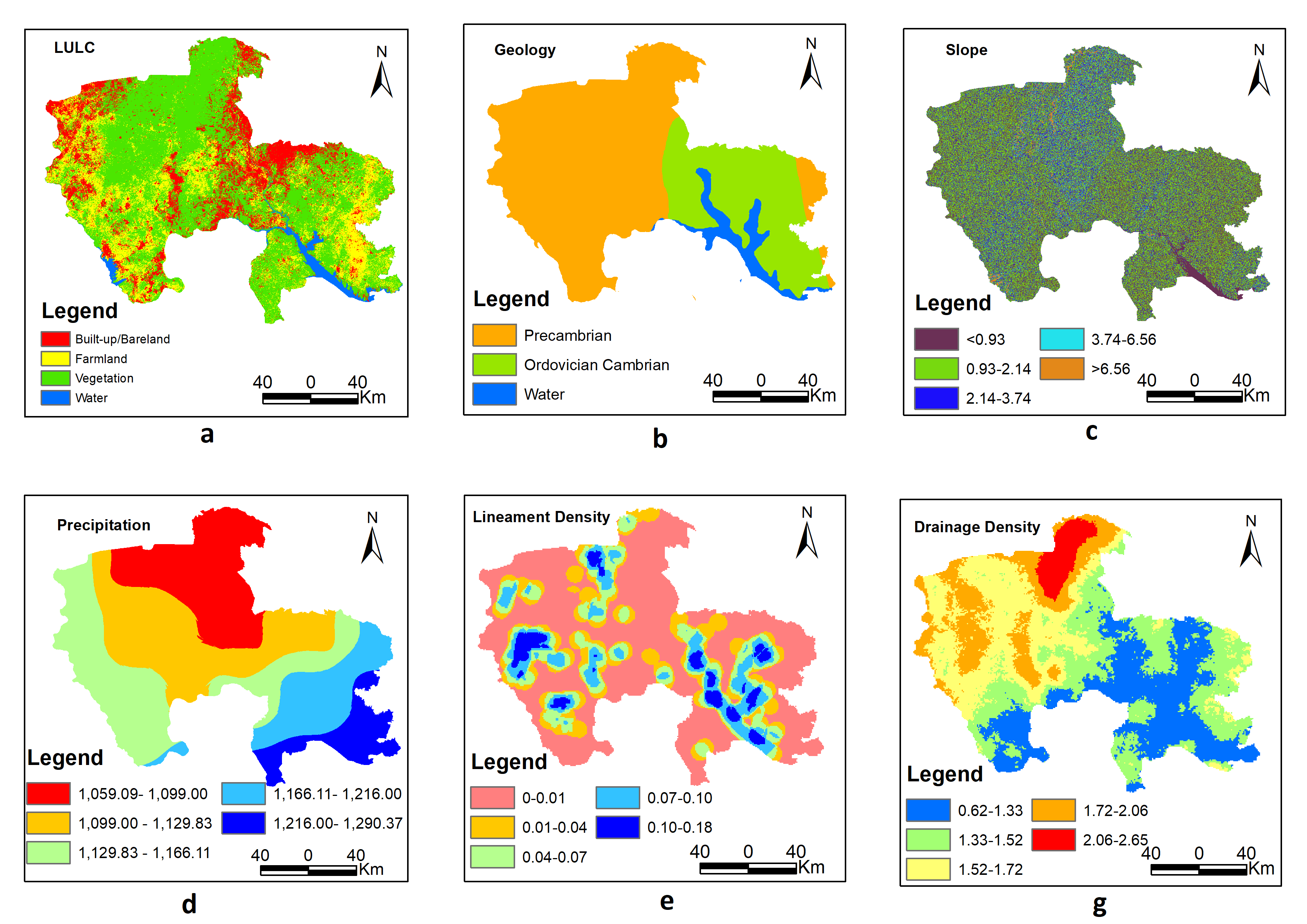
AHP-Geospatial Estimation of Groundwater Potential Zones for Sustainable Agriculture
- Tools:ArGIS Pro Key Tasks:
- Identified and studied literature related to the topic
- Gathered and prepared the key datasets for the analysis of the various contributing factors
- Used GIS-based Multi-Criteria Decision Making (MCDM) techniques to estimate groundwater potential zones for irrigation agriculture in the Savannah Region of Ghana.
- Performed weighted overlay analysis technique in ArcGIS to create the map of the groundwater potential zones.
- Developed a graphical abstract
- Made recommendations for stakeholders in groundwater development for irrigation agriculture, aiming to ensure sustainable crop cultivation in farming communities
Skills
GIS Software & Solutions
 ERDAS
ERDAS
 ArcGIS Pro
 ArcGIS Online
 QGIS
QGIS
 R
R
 MATLAB
 Enterprise Architect
Data Visualization
 Power BI
 Tableau
 Adobe Illustrator
Languages and Databases
 HTML
HTML
 SQL
SQL
Libraries
 GeoPandas
Frameworks
Other
 Git
Git
 GitHub
 Open Data Kit
 MapStore
 MapServer
 GeoServer
Education
Hochschule für Technik Stuttgart
Stuttgart, Germany
Degree: Master of Science in Photogrammetry and Geoinformatics
Ongoing
- GIS
- Database Systems and Design
- Geostatistics & Surface Modeling
- Project Planning & Management
- Remote Sensing
- Photogrammetry
- GIS Programming
- Customization, Internet GIS, & Visualisation
Relevant Courseworks:
Kwame Nkrumah University of Science and Technology
Kumasi, Ghana
Degree: Bachelor of Arts in Geography & Rural Development
Grade: First Class Honours
- GIS
- Remote Sensing
- Cartography & Map Design
- Introduction to Computers
- Research Methods in Geography
- Environmental Management
- Map Interpretation & Fundamentals of Surveying
Relevant Courseworks: